37° 48' 15.7068'' N, 122° 16' 15.9996'' W
cloud-native gis has arrived
37° 48' 15.7068'' N, 122° 16' 15.9996'' W
cloud-native gis has arrived
37° 48' 15.7068'' N, 122° 16' 15.9996'' W
cloud-native gis has arrived
37° 48' 15.7068'' N, 122° 16' 15.9996'' W
cloud-native gis has arrived
37° 48' 15.7068'' N, 122° 16' 15.9996'' W
cloud-native gis has arrived
37° 48' 15.7068'' N, 122° 16' 15.9996'' W
cloud-native gis has arrived
37° 48' 15.7068'' N, 122° 16' 15.9996'' W
cloud-native gis has arrived
37° 48' 15.7068'' N, 122° 16' 15.9996'' W
cloud-native gis has arrived
37° 48' 15.7068'' N, 122° 16' 15.9996'' W
cloud-native gis has arrived
37° 48' 15.7068'' N, 122° 16' 15.9996'' W
cloud-native gis has arrived
Introducing Felt AI, your built-in team of spatial engineers Learn more
Island-like shape.
The spatial platform your whole team can actually use
Carto wasn't built for everyone who needs geospatial data. Felt is — so your whole team gets direct access to spatial data, without the SQL workarounds, suprise warehouse bills, PS dependency, or raster trade-offs.
Compare what you can do: Felt vs. Carto
Felt
ArcGIS Online
Section Title
Ease of use
Deployment
Data Integrations
AI
Raster Support
Collaboration
Pricing
Security
Open Source
Mobile
Section Title
Share via URL
Share via URL

Your whole team, not just SQL experts

Your data analysts, GIS managers, and sales teams can all build maps, apps, and dashboards — together, in real time. No SQL required.

Complete GIS: Vector + Raster

Raster isn't optional. It's part of real GIS work. Felt handles both natively — no conversions, no compromises.

predictable cost

Felt pre-tiles your data once — so your costs don't compound every time someone opens a map. No guessing games with your warehouse bill.

From idea to app in seconds

Build complete Felt-native applications with just a prompt. Deploy immediately.

  • Prompt your way to powerful extensions
  • Turn any map into a polished applications
  • Your data stays protected

Power your tools directly from the source

Build apps, maps, and dashboards with data your team can rely on.

  • Create map layers from your sources
  • Set data update frequency
  • Embed in notebooks or applications

Streamline field data collection

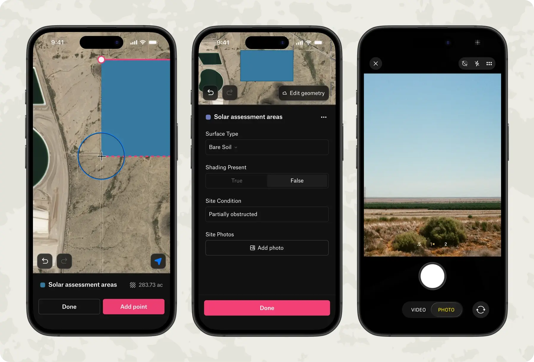
Felt's mobile app turns any device into a complete field collection tool, with no configuration or training required.

  • Create custom surveys that standardize what your team collects in the field for documenting assets, inspections, or observations
  • Capture points, lines, and areas with automatic location tracking and GPS precision
  • Add visual context by attaching geotagged photos directly to features and comments, capturing conditions exactly as they exist
  • Work offline anywhere—when you're back in range, data syncs and is ready to analyze and share
Book a demo
Start free trial
Know what you’re getting without complex consumption model.

Priced for simplicity

Felt dashboards make insights easy to consume-at-a-glance with powerful visualization features.

  • Add to Tableau, PowerBI, and Retool
  • Embed on internal platforms like Sharepoint and more
  • Share results with a single link

Complicated, opaque packaging

Felt dashboards make insights easy to consume-at-a-glance with powerful visualization features.

  • Add to Tableau, PowerBI, and Retool
  • Embed on internal platforms like Sharepoint and more
  • Share results with a single link
"For anyone needing to deliver mapping products quickly, I'd be hard-pressed to recommend anything else."
"I find Felt the quickest and easiest way to have planners and analysts visualize data."
"Felt allows us to more efficiently assess where our pickup requests come in."
Frequently Asked Questions

Can I use Felt alongside ESRI?

Lorem ipsum

How long does it take to get started?

Lorem ipsum

Is Felt secure?

Lorem ipsum

What will happen to my data in ESRI?

Lorem ipsum

Start creating maps today
Introducing Felt AI, your built-in team of spatial engineers Learn more