37° 48' 15.7068'' N, 122° 16' 15.9996'' W
cloud-native gis has arrived
37° 48' 15.7068'' N, 122° 16' 15.9996'' W
cloud-native gis has arrived
37° 48' 15.7068'' N, 122° 16' 15.9996'' W
cloud-native gis has arrived
37° 48' 15.7068'' N, 122° 16' 15.9996'' W
cloud-native gis has arrived
37° 48' 15.7068'' N, 122° 16' 15.9996'' W
cloud-native gis has arrived
37° 48' 15.7068'' N, 122° 16' 15.9996'' W
cloud-native gis has arrived
37° 48' 15.7068'' N, 122° 16' 15.9996'' W
cloud-native gis has arrived
37° 48' 15.7068'' N, 122° 16' 15.9996'' W
cloud-native gis has arrived
37° 48' 15.7068'' N, 122° 16' 15.9996'' W
cloud-native gis has arrived
37° 48' 15.7068'' N, 122° 16' 15.9996'' W
cloud-native gis has arrived
Ask a question. Get a map. The new era of GIS, powered by Felt AI. Learn more
Island-like shape.
Full GIS access with or without Esri ArcGIS
Felt is an AI-native GIS platform designed for teams who need to move fast, collaborate in real time, and build powerful maps and apps without the cost and limitations of legacy GIS.
Compare what you can do: Felt vs. Esri ArcGIS
Felt
Esri ArcGIS
Ease of use
Felt
Built for your entire team, from data and GIS teams to operations and leadership. Create powerful maps without SQL knowledge or GIS training.
Carto
Built for specialist teams only.  Creates bottlenecks for your broader team.
Cloud-native architecture
Felt
Cloud-native from day one, Nothing to install, no technical  requirement, no servers to maintain.
Carto
Legacy infrastructure with bolted on solutions that make it difficult to move quickly.
Data Integrations
Felt
Connects to Snowflake, BigQuery, Databricks, Redshift, Postgres, and S3 directly, plus native connections to ArcGIS Online, ArcGIS Enterprise, and public Esri REST services.
Carto
Limited data connectivity that requires complex technical set-up and constant manual management.
Open Source
Felt
Built on the tools the GIS community already trusts. Felt maintains Tippecanoe, renders on MapLibre, funded PMTiles development at Protomaps, and has a direct QGIS plugin.
Carto
Built on proprietary formats designed to keep you inside the solution and keep your data hard to move.
AI Features
Felt
Create maps, run spatial queries, and analyze data using natural language. Easily integrate Felt into your existing AI stack through Felt MCP.
Carto
AI assistants built to guide rather than act. Limited MCP access and capabilities.
App building
Felt
Build and ship maps, apps and dashboards in minutes, not weeks.
Carto
Configuration-heavy workflows with lengthy and complex implementation.
Access
Felt
One plan for your whole team. No per-role license tiers, no credit system to monitor.
Carto
Cost that increases with every new seat and every new viewer.
Collaboration
Felt
Real-time collaboration that keeps your whole team working together — co-edit, comment, and share with stakeholders without leaving the map.
Carto
No real-time collaboration that keeps your team siloed instead of working together.
Felt works as a full alternative to ArcGIS or right alongside your existing Esri investment. Connect your warehouse, analyze with AI or SQL,  and give the rest of your organization spatial access without buying a license for every person who needs to see a map.

Replace your ArcGIS with Felt

Web-based mapping, spatial analysis, dashboards, apps, and field data collection in one platform. No desktop install, no complex licensing models, real-time collaboration from the start.

Add Felt to your Esri infrastructure

Felt connects directly to ArcGIS Online, ArcGIS Enterprise, and any public Esri Feature, Map, or Image Server. No exporting, no duplicating. You can keep ArcGIS Pro workflows you already have, while also adding a more interactive and collaborative access without extra paid ArcGIS seats.
Felt is built so your team owns the process, controls the costs, and has a complete GIS from day one — without the workarounds.

GIS for your entire team

Analysts, planners, leadership, field crews. One workspace, one plan, no per-role license math.

End-to end solution

SDK, dashboards, embeds, and AI-assisted tools. Everything you need to go from geospatial data to live maps, apps, and dashboards — fast, in one platform.

Real-time collaboration

Every map in Felt is multiplayer. Co-edit with your team and easily share with the public with just one link. No more silos.

From idea to app in seconds

Build complete Felt-native applications with just a prompt. Deploy immediately.

  • Prompt your way to powerful extensions
  • Turn any map into a polished applications
  • Your data stays protected

Power your tools directly from the source

Build apps, maps, and dashboards with data your team can rely on.

  • Create map layers from your sources
  • Set data update frequency
  • Embed in notebooks or applications

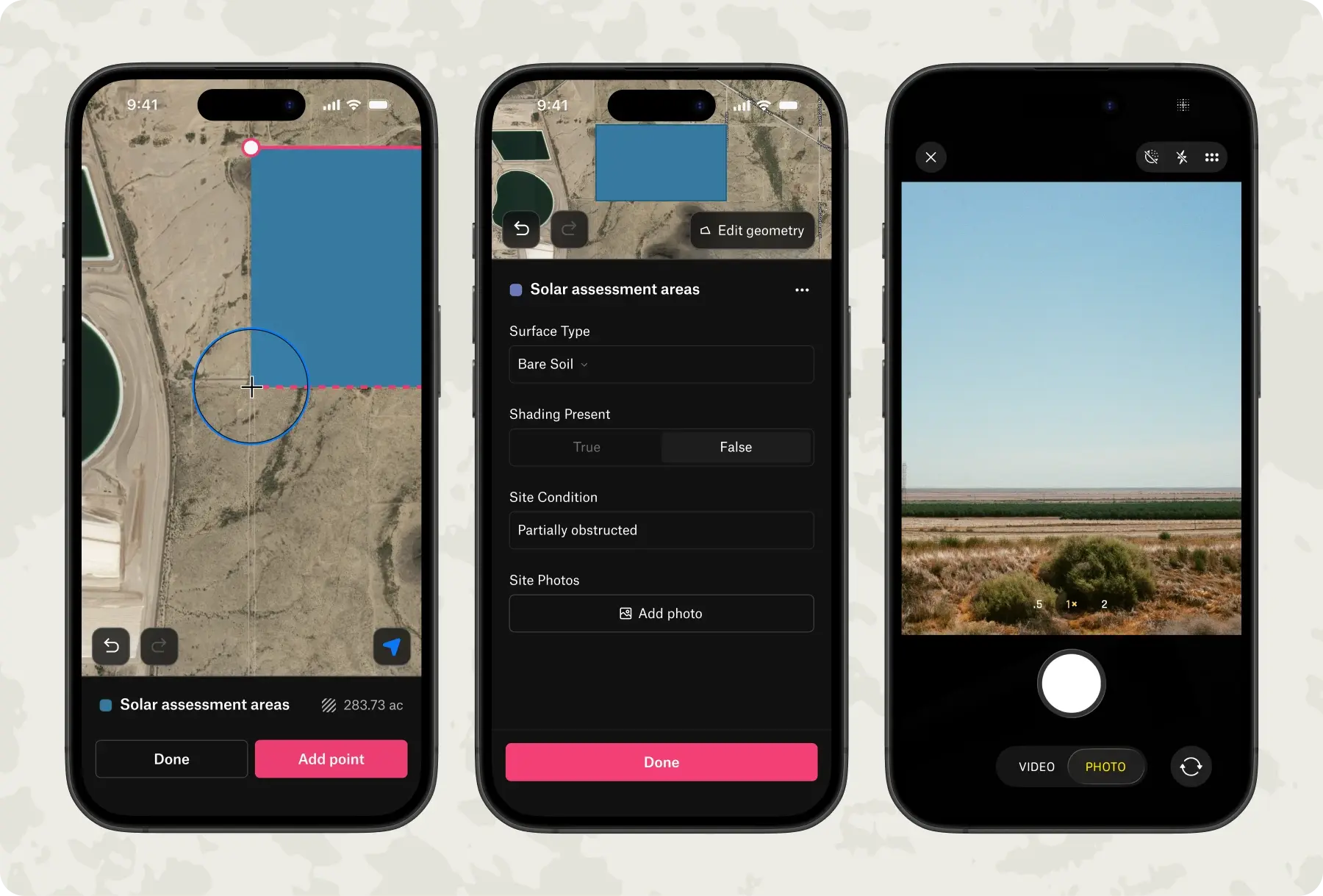
Streamline field data collection

Felt's mobile app turns any device into a complete field collection tool, with no configuration or training required.

  • Create custom surveys that standardize what your team collects in the field for documenting assets, inspections, or observations
  • Capture points, lines, and areas with automatic location tracking and GPS precision
  • Add visual context by attaching geotagged photos directly to features and comments, capturing conditions exactly as they exist
  • Work offline anywhere—when you're back in range, data syncs and is ready to analyze and share
Book a demo
Start free trial
Our engineering team is behind some of the industry standard tools that help turn your geospatial data into high-performance maps. Felt is built on MapLibre and Tippecanoe, alongside a QGIS integration, so data engineers and developers get a platform grounded in the open standards and tools the GIS community already trusts.
"What used to take us two weeks of development now takes about an hour with Felt."
"For anyone needing to deliver mapping products quickly, I'd be hard-pressed to recommend anything else."
"I find Felt the quickest and easiest way to have planners and analysts visualize data."
Frequently Asked Questions

Can Felt connect to the same cloud warehouses as CARTO?

Yes. Felt connects to Snowflake, BigQuery, Databricks, Redshift, and Postgres. The key difference: Felt pre-tiles your data once, so your team can explore maps without triggering warehouse queries on every interaction. Felt is also an official partner of AWS, Databricks, and Wherobots — so your existing stack is well supported.

Can Felt support both technical data teams and non-technical stakeholders at the same time?

Yes. Felt offers direct SQL querying for data teams who want it, alongside a no-code interface for everyone else. Technical and non-technical users work in the same environment, on the same maps, in real time.

Does Felt support raster data like elevation or satellite imagery?

Yes — fully. Felt supports streaming COGs, STAC catalogs, and S3 auto-indexing.We're a complete GIS platform for both raster and vector

How quickly can my team get started with Felt?

Most teams are up and running the same day — no setup, no implementation project, no professional services required. Connect your data source, build your first map, and share it with your team in minutes. And when you're ready to build more — dashboards, apps, embeds — Felt's SDK and no-code tools mean your team owns the process end to end, without needing outside help.

Join 500+ teams across industries building powerful maps, apps, and dashboards today.

Why teams choose Felt as their CARTO alternative for enterprise GIS

Enterprise GIS software your whole team can actually use

Felt offers direct SQL querying for data teams who want it, alongside a no-code interface for everyone else. Technical and non-technical users work in the same environment, on the same maps, in real time.

Predictable GIS costs that don't compound as you scale

CARTO queries your data warehouse on every interaction with the map triggering constant charges blocking you from freely scaling your work. Felt pre-tiles your spatial datasets once, so your team runs advanced GIS workflows at no additional compute cost. Teams switching from CARTO report significant savings on their annual GIS software spend.

Complete GIS platform for advanced raster and vector spatial analysis

CARTO's limited raster support means teams working with satellite imagery or elevation models are forced into workarounds or additional tooling. Felt is a complete GIS software platform with full native raster and vector support including streaming COGs, STAC catalog access, and S3 auto-indexing. One platform for all your geospatial data, without workarounds.

Powerful GIS your team owns from day one — no PS required

CARTO's architecture can often block even standard GIS workflows and require additional support. Felt is self-serve from day one — allowing teams of all sizes and GIS expertise to ship spatial analysis dashboards and GIS mapping applications within 48 hours, without PS, complex SDKs, or writing a single line of code.
Ask a question. Get a map. The new era of GIS, powered by Felt AI. Learn more