37° 48' 15.7068'' N, 122° 16' 15.9996'' W
MODERN MAP MAKING HAS ARRIVED
37° 48' 15.7068'' N, 122° 16' 15.9996'' W
MODERN MAP MAKING HAS ARRIVED
37° 48' 15.7068'' N, 122° 16' 15.9996'' W
MODERN MAP MAKING HAS ARRIVED
37° 48' 15.7068'' N, 122° 16' 15.9996'' W
MODERN MAP MAKING HAS ARRIVED
37° 48' 15.7068'' N, 122° 16' 15.9996'' W
MODERN MAP MAKING HAS ARRIVED
37° 48' 15.7068'' N, 122° 16' 15.9996'' W
MODERN MAP MAKING HAS ARRIVED
37° 48' 15.7068'' N, 122° 16' 15.9996'' W
MODERN MAP MAKING HAS ARRIVED
37° 48' 15.7068'' N, 122° 16' 15.9996'' W
MODERN MAP MAKING HAS ARRIVED
37° 48' 15.7068'' N, 122° 16' 15.9996'' W
MODERN MAP MAKING HAS ARRIVED
37° 48' 15.7068'' N, 122° 16' 15.9996'' W
MODERN MAP MAKING HAS ARRIVED
Maps
Editorial
The woman behind that Amtrak map
Michelle Jennings has over a decade of GIS experience. Before joining Felt she was at Amtrak and her map of the 2035 train network went viral overnight.

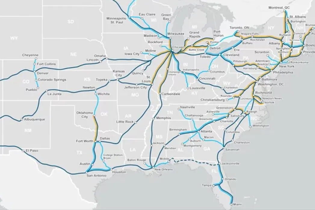
You are the woman behind Amtrak’s 2035 map–the map that went viral during the election. What was that like?

Thanks for asking me about this because someone could look at that map and think it took a few days to make, but really it’s the culmination of many many years of work. When I first showed up at the agency, there was not a complete GIS network of all the routes we operated on. We had engineering documents, but nothing geospatial, certainly not outside of the rails owned and operated by Amtrak (mainly the northeast corridor). The first thing I did was get the geospatial network files from our partners and the Federal Railroad Administration who ran other parts of the network, and then worked with two incredible colleagues to get the mileposts out of their heads (!!) and onto a map. 

As the GIS person in a large agency, most of my work is never seen, so I was surprised see this map get shared publicly and then delighted to see it move people. I had made the map for another ongoing planning project, but when the call came that we needed something that could depict our plans for 2035, the bird in the hand was what we ran with. It’s truly a story of years of data preparation, and then being in the right place at the right time. Then, to see my work at the center of a nationwide discussion about the future of train travel in this country, that was really something. I feel so lucky to have had that experience to expose the world to my work.

You’ve worked on other incredible projects. Tell me about some other unexpected career highlights.

Protecting the Pope during his trip along the Northeast Corridor was the highlight of my career to date! I made so many maps of the different locations he would be stopping at–situational awareness, entrance and egress, you name it, the map was the centerpiece of the entire effort. It was even more exciting than helping President Obama and then [Vice] President Biden get from Philadelphia to Washington D.C. for inauguration!

It was an incredible feeling to watch him get in and out of his little Fiat and know that I played a role helping the whole event unfold. 

...to see my work at the center of a nationwide discussion about the future of train travel in this country, that was really something.

How did you start your career in Geospatial Information Systems (GIS)?

Finding a career in maps is really a silver lining to what otherwise is a sad story. I went to the University of Texas (hook ‘em!) and really liked architectural engineering. I was on track to be a civil engineer, but there were only five female engineers in a cohort of about 500. We were actively discriminated against–left out of group work, that type of stuff, and it was very uncomfortable to learn in that environment.   

I found the things I loved about civil engineering–the combination of math and drawing–in the geospatial community. The shift to the field of GIS/Cartography was one of the best decisions of my life.  Our projects were incredibly interesting, yet challenging, with the added bonus of learning more about our planet. It is a great fit for me and it was a new field at the time. There was no model for success, so I was really taking a chance. But I followed my heart and left the world of civil engineering behind. I hope it’s changed, but I also never cared enough to look back because I’ve enjoyed myself so much ever since.

The Northeast Corridor is very vulnerable to sea level rise. Tell me about your experience working helping an agency map assets under threat.

Amtrak is all about sustainability, and I played an active role depicting what sea level rise would mean for our assets. Using a beautiful raster dataset of where the water level will be in 2050, we overlaid the topography and infrastructure to understand where we would need to focus our adaptation efforts. There were several big stations projected to be underwater by 2050 and it was a big shock. Maps can be really catalyzing in this way–helping people understand how infrastructure, homes, logistics, and thereby lives and livelihoods will be impacted if we don’t start planning and take action today. 

What excites you about what we are doing at Felt?

The way we make maps today is broken. As a GIS expert with over a decade of experience, I know that map making has gotten lightyears easier over my career–and I'm also very aware that it's still too hard for most. Everywhere I've worked I've been met with long queues of staff asking for help with simple tasks, screenshots of aerials in emails going back and forth, and people who show up with drawings on paper, asking me to transpose this into geospatial information. We have a long way to go. The Felt team deeply understands that designing a solution that most people can use will look and feel different radically different than anything we have seen in the past, and I am thrilled to go to work every day to build something that will surely be transformative, and allow more people to think geospatially. I have been so lucky to have had that experience to influence national discourse through a single map–I want other people to have that experience.

It was an incredible feeling to watch [the Pope] get in and out of his little Fiat and know that I played a role helping the whole event unfold.
Bio
Michelle Jennings has over a decade of experience providing high-stakes GIS support for public safety. Michelle's work spans other industries as well, including fire, environmental engineering, oil and gas. Before joining Felt, Michelle was at Amtrak Police, Security and Counter-Terrorism, where she provided security support to protect people like President Obama, President Biden and Pope Francis. Some of her more public facing work includes the Amtrak 2035 Vision for the network which went viral during the 2020 election, and her sustainability work to help stations stay open and functioning as sea level rise increases. She is a Longhorn (hook 'em!) and a championship Blackjack player who enjoys spending time with her family.
LinkedIn
More articles

Cartography Tips for Designing Web Maps

Search, filter, select — data discovery done right

Getting the most out of Felt’s new Workspaces

Teaching Spatial Analysis with Felt

Powerful new admin tools and a streamlined billing experience

Three key UI upgrades in Felt 2.0